
A magnitude 9.0 earthquake occurred on March 11, 2011 at 14:46 JST. An emergency rescue helicopter “Michinoku” was scrambled from Sendai Airport 37 minutes after the occurrence of the earthquake. A few minutes later, Sendai Airport was engulfed by tsunami. Live coverage of damage and tsunami by the rescue helicopter Michinoku provided a great deal of important information to determine our response to the disaster. For further details, see here.
Occurrence of the Earthquake and Approaching Tsunami
The situation of the Great East Japan Earthquake
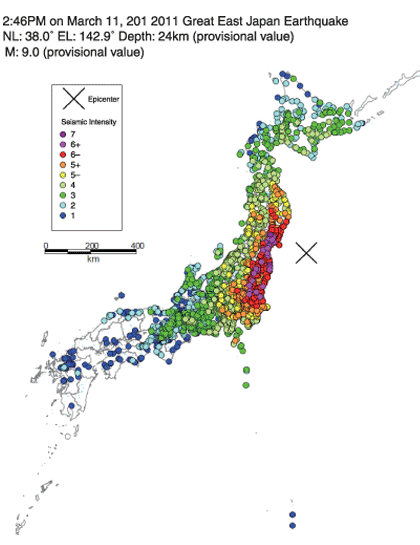
On Friday, March 11, 2011 at 14:46 JST, a massive earthquake struck Japan.
The earthquake had a magnitude of 9.0 and a maximum seismic intensity of 7.
A massive earthquake struck eastern Japan, mainly the Tohoku region. An intensity of 7 was recorded in Kurihara of Miyagi Prefecture, and 6 or greater in prefectures of Miyagi, Fukushima, Ibaragi, and Tochigi. The earthquake had a magnitude of 9.0, which was the largest in the recorded history of Japan.
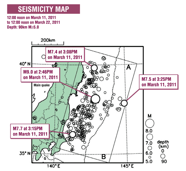
The Great East Japan Earthquake was an earthquake of an interlocked or interlinked type, where four mega-earthquakes including the main shock occurred intermittently. Mega-earthquakes with a magnitude of 7.0 or greater occurred in the area extending from off the Sanriku Coast to Off Ibaragi Prefecture during 40 minutes after the main shock.
Many aftershocks occurred; more than 400 aftershocks with a magnitude of 5.0 or greater had been registered in one month. Epicenters clustered in a large area extending from Off Iwate Prefecture to Off Ibaragi Prefecture, measuring about 500 km from north to south and about 200 km from east to west.
Earthquake Summary
| Date and Time | On Friday, March 11, 2011 at 14:46 JST |
|---|---|
| Hypocenter | Sanriku Offshore (N38.1, E142.9, 130km ESE off Oshika Peninshula) Depth 24km |
| Magnitude | 9.0 |
| Name of the earthquake | The 2011 earthquake off the Pacific coast of Tōhoku |
| JMA Seismic Intensity | Intensity 7: The northern part of Miyagi Prefecture Intensity 6 upper: The southern part and central part of Miyagi Prefecture, The Nakadori and Hamadori area of Fukushima Prefecture, The northern part and southern part of Ibaraki Prefecture, The northern part and southern part of Tochigi Prefecture Intensity 6 lower: The coastal southern part, inland northern part, and inland southern part of Iwate Prefecture, Aizu area of Fukushima Prefecture, The southern part of Gunma Prefecture, The southern part of Saitama Prefecture, The northwestern part of Chiba Prefecture |
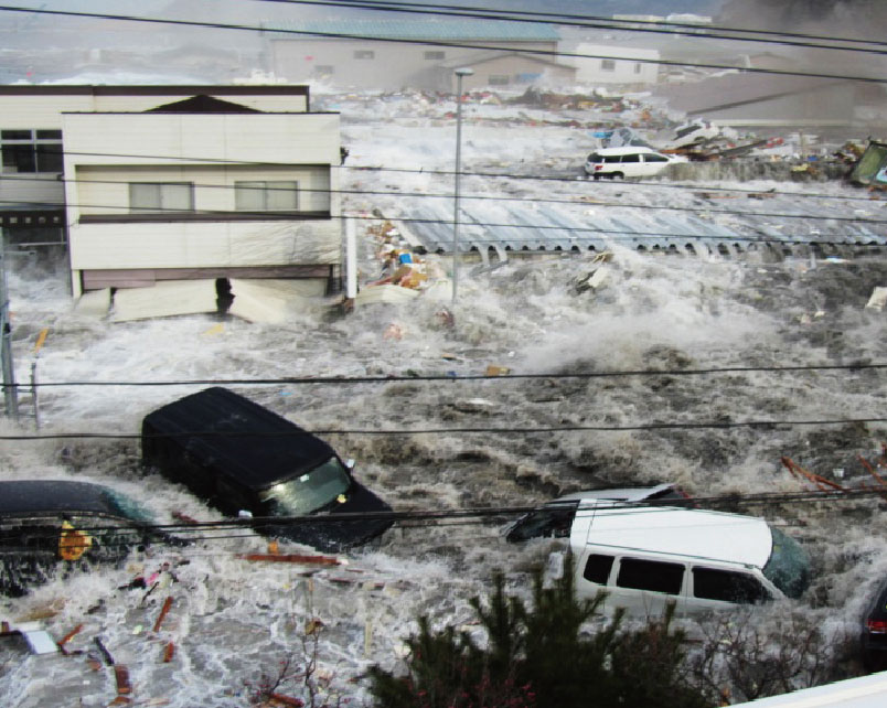
A massive tsunami struck the Pacific coast of east Japan.
The biggest tsunami in the recorded history of Japan struck the coastal area of the Tohoku region.
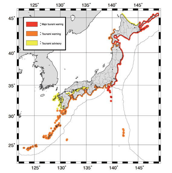
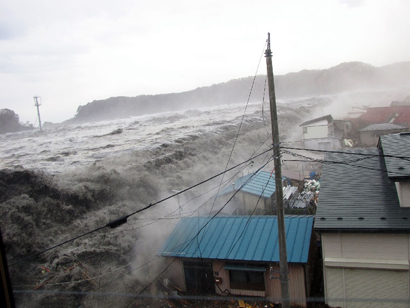
Immediately after a strong earthquake struck the Tohoku region, the massive tsunami hit the Pacific coast of the Hokkaido, Tohoku, and Kanto regions. The tsunami which struck the coasts reached more than 10 m in height, leaving behind the unprecedented damage. Later survey showed that the height of tsunami depended on the topography of shore or bay, and hence the damage also varied in extent.
The tsunami climbed a slope in some places. The tsunami hit Miyako of Iwate Prefecture reached more than 39 m above sea level, which was the highest ever in the recorded history, surpassing the height of 38.2 m observed in Ōfunato of Iwate Prefecture back in the 1896 Sanriku earthquake.
Tsunami Summary
[Major Tsunami Warnings]
The Hokkaido Pacific coast eastern area, the Hokkaido Pacific coast central area, the Hokkaido Pacific coast western area, The Aomori Pacific coast, Iwate, Miyagi, Fukushima, Ibaragi Prefectures, Kujukuri Sotobo of Chiba Prefecture, the Izu Islands (As of March 11, 15:33 JST)
[Height of the tsunami] * estimated using the corresponding tsunami trace heights
| Hachinohe (Aomori Prefecture) | 6.2m | Ōfunato (Iwate Prefecture) | 11.8m |
| Kuji Port (Iwate Prefecture) | 8.6m | Ayukawa, Ishinomaki City (Miyagi Prefecture) | 7.7m |
| Miyako (Iwate Prefecture) | 7.3m | Sendai Port (Miyagi Prefecture) | 7.2m |
| Kamaishi (Iwate Prefecture) | 9.3m | Sōma (Fukushima Prefecture) | 8.9m |
Source: Japan Meteorological Agency
Run-up height of the tsunami
Iwate Prefecture (former Taro Town)
| Miyako (Iwate Prefecture) | 39.211m |
|---|---|
| Kamaishi (Iwate Prefecture) | 30.480m |
| Ōfunato (Iwate Prefecture) | 31.839m |
| Rikuzentakata (Iwate Prefecture) | 22.184m |
| Kesennuma (Miyagi Prefecture) | 22.671m |
| Minamisanriku (Miyagi Prefecture) | 20.408m |
| Sōma (Fukushima Prefecture) | 21.303m |
Source: Preliminary results by the “2011 Tohoku Earthquake Tsunami Joint Survey Group” (December 15, 2011)
http://www.coastal.jp/ttjt/
*Reliability A (High reliability. Data with a clear trace and the least error in measurement.)
Complete destruction 128,931 houses Half destruction 269,040 houses
Source: the Tohoku Regional Bureau
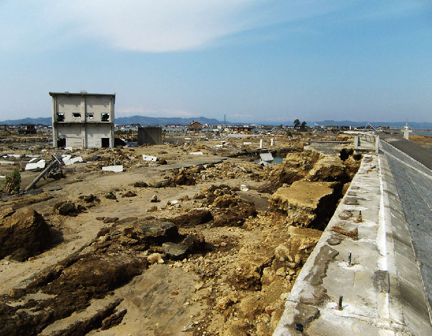
It was the unprecedented scale of disaster, which claimed nearly 20,000 lives, including the missing.
The strong earthquake and subsequent massive tsunami devastated the area along the Pacific coast, claiming nearly 20,000 lives, including the missing, leaving behind more than 330,000 evacuees.
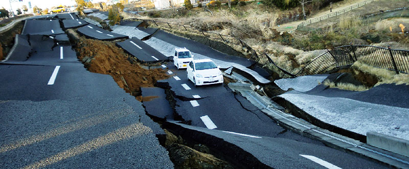
They also caused extensive destruction: they ruined houses completely, swept away roads and bridges or collapsed them, wrecked levees totally, etc.
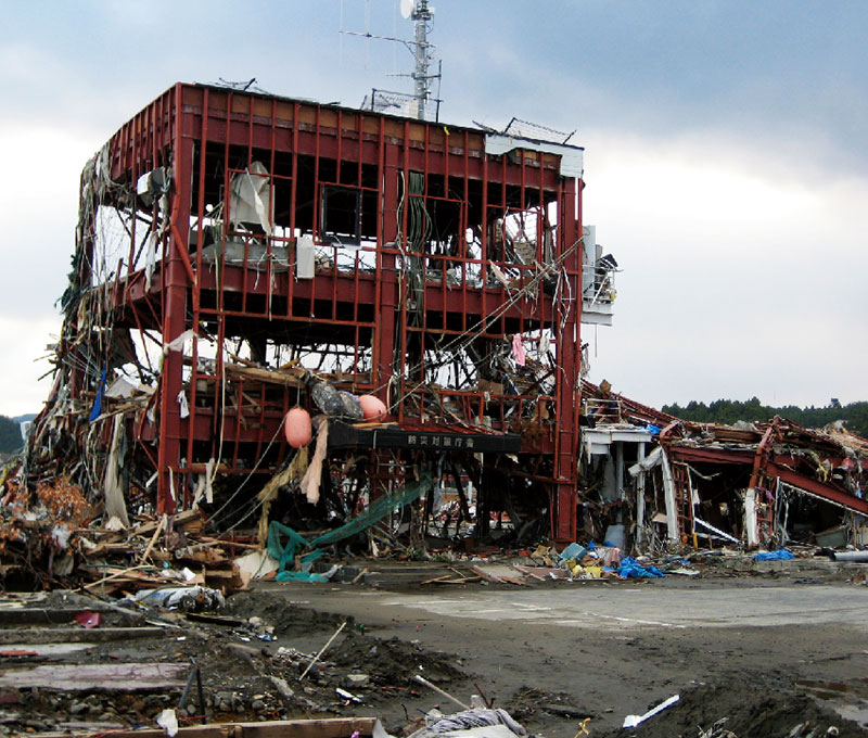
Some municipal office buildings, which were supposed to become headquarters of disaster response, were also affected. Route 45, 4 and 6 along the Pacific coast were cut in several places, which isolated many municipalities along the coast.
Damage statistics
| Deaths and missing persons | Deaths 15,880 / Missing 2,694 (Source: the Emergency Disaster Response Headquarters, February 2013) |
|---|---|
| Damage to buildings (residential) (住家) |
Complete destruction 128,931 houses / Half destruction 269,040 houses / Partial destruction 736,227 houses (Source: the Emergency Disaster Response Headquarters, February 2013) |
| Number of evacuees | 315,196 (Source: the Emergency Disaster Response Headquarters, February 2013) |
| Damage to rivers | 2,115 facilities (Source: the Ministry of Land, Infrastructure, Transport and Tourism, May 2011) |
| Damage to levees and revetments | Complete and half destruction: about 190 km out of total 300 km levees and revetments in the three prefectures of Iwate, Miyagi, and Fukushima. (Source: the Ministry of Land, Infrastructure, Transport and Tourism, May 2011) |
| Damage to ports and harbors | International hub ports/important ports and harbors 11 / Regional ports and harbors 18 (Source: the Ministry of Land, Infrastructure, Transport and Tourism, May 2011) |
| Damage to sewage treatment plants | Plants suspended operations 18 (the sewage plants in the coastal areas of the prefectures of Iwate, Miyagi, Fukushima, and Ibaragi) Pipes and culverts: 957 km out of total 66,086 km sewer in 137 municipalities. (Source: the Ministry of Land, Infrastructure, Transport and Tourism, May 2011) |
| Damage to roads | Freeway 15 routes National highways under direct control of the Japanese Government 69 sections National highways under control of prefectures 102 sections Prefectural roads 539 sections (Source: the Ministry of Land, Infrastructure, Transport and Tourism, May 2011) |
| Flooded area due to tsunami | Iwate Pref. 580,000 km2 Miyagi Pref. 3,270,000 km2 Fukushima Pref. 1,120,000 km2 (Source: the Ministry of Land, Infrastructure, Transport and Tourism, May 2011) |
Bridges washed away, roads destroyed.
Route 45 and other roads were cut along the Pacific coast
The roads were particularly damaged by the massive earthquake and tsunami Route 45 was especially affected with parts of it along the Pacific coast connecting Aomori, Iwate and Miyagi prefectures completely destroyed or overflown. Route 6 connecting Miyagi and the southern part of Fukushima prefecture was also blocked due to many points of collapse. Even a couple of inland prefectural roads suffered collapses. With the roads along Pacific Ocean coast rendered impassable the disaster areas were isolated from any rescue and relief.
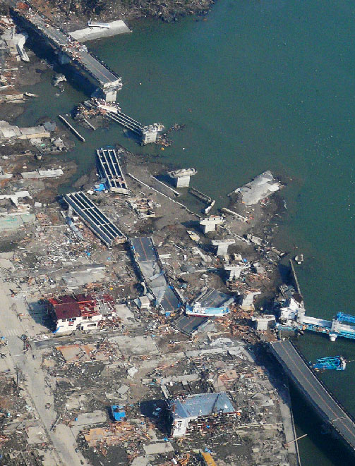
Utatsu Ohashi Bridge, aerial shot
Source: the MLIT Tohoku Regional Bureau
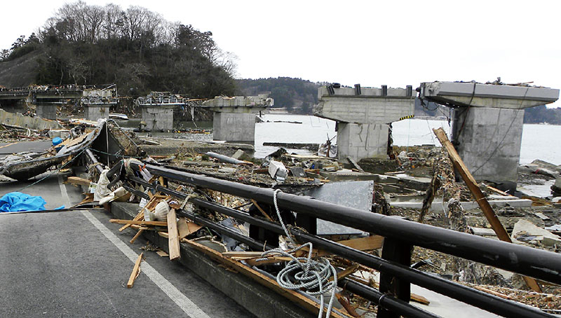
Utatsu Ohashi Bridge washed away
Source: the MLIT Tohoku Regional Bureau
Collapsed Route 6
Source: the MLIT Tohoku Regional Bureau
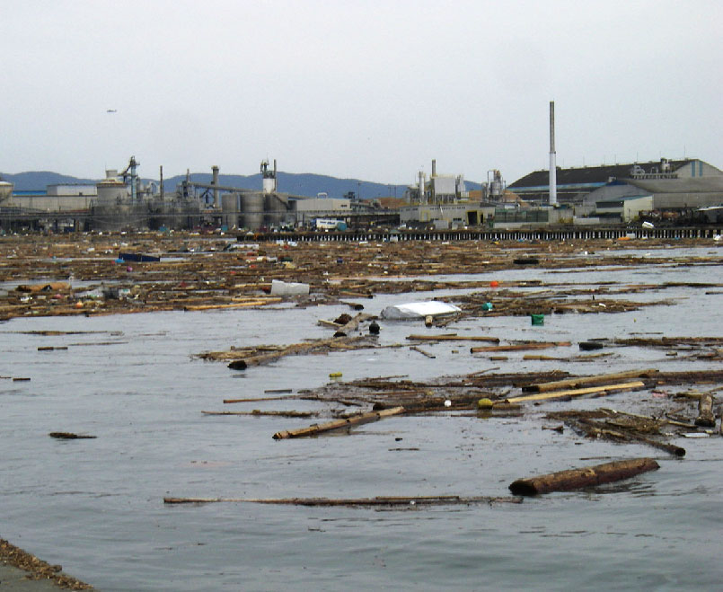
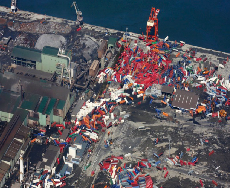
Ports out of order
Uncountable amount of debris was washed into the bay from the destroyed port facilities.
Many ports, including Miyako, Kamaishi and the Tohoku’s largest Sendai Shiogama, suffered massive damage from the earthquake and tsunami. Ship berthing areas and cargo handling cranes were seriously damaged with breakwaters completely obliterated. Much debris was washed away into the bay area leading to a complete halt of any vessel admission to the area. With the transportation network along the bay blocked all maritime logistics were rendered impossible. On top of that, with the major tsunami warning, tsunami warning, and alert going on for three days straight no one could even get close to the coastal area.
Utatsu Ohashi Bridge, aerial shot
Source: the MLIT Tohoku Regional Bureau
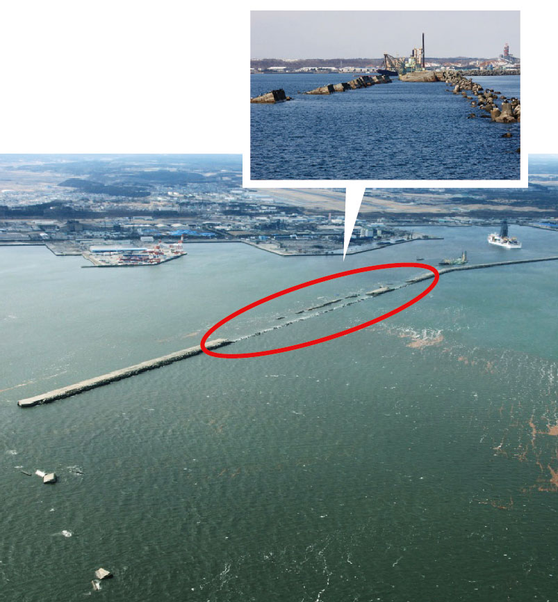
Destroyed north breakwaters
Source: the MLIT Tohoku Regional Bureau
Utatsu Ohashi Bridge washed away
Source: the MLIT Tohoku Regional Bureau
Collapsed Route 6
Source: the MLIT Tohoku Regional Bureau
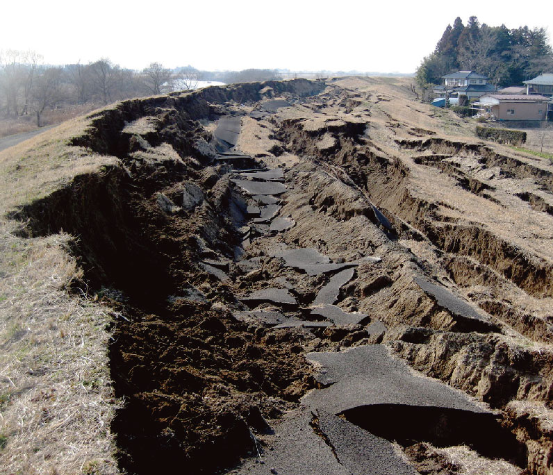
Levees of rivers and coasts collapsed, washed away.
Levees of the south Sendai Bay coast and many of rivers were washed away.
Levees of coasts and rivers were massively damaged by the earthquake and tsunami. For about 50 km along the south Sendai Bay coast most levees were washed away or deformed beyond recognition. Furthermore most of the river levees at the estuaries of Kitakamigawa River and Abukumagawa River were also washed away or completely eroded by the tsunami. Many levees upstream were also cracked by the earthquake or even crushed and liquefied causing subsidence. Some of those levees were also supporting roads making their reconstruction of vital importance for the isolated disaster area.
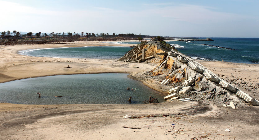
Levees washed away along the south Sendai Bay coast
Source: the MLIT Tohoku Regional Bureau
Eroded or washed away levees of Abukumagawa River right bank
Source: the MLIT Tohoku Regional Bureau
Large-scale subsidence of levees upstream of Narusegawa River
Source: the MLIT Tohoku Regional Bureau